Sustainable Groundwater Management Act
SUSTAINABLE GROUNDWATER MANAGEMENT ACT
The Sustainable Groundwater Management Act (SGMA) of 2014 created a statewide framework to help protect groundwater resources over the long-term. SGMA is comprised from a three-bill legislative package, including AB 1739 (Dickinson), SB 1168 (Pavley), and SB 1319 (Pavley), and subsequent statewide Regulations. SGMA requires local agencies form groundwater sustainability agencies (GSA’s) for high and medium priority basins. GSA’s are required to then develop and implement groundwater sustainability plans (GSP’s) to avoid undesirable results and mitigate overdraft within 20 years. Low priority basins are not required to form GSA’s or GSP’s at this time. The Mojave Water Agency is a low priority basin that is not required to form a GSA or GSP. Additionally, MWA is exempt from this requirement due to the adjudication (see below).
The State Department of Water Resources (DWR) serves as the administrator for SGMA implementation. DWR provides regulatory oversight through the evaluation and assessment of GSPs. SGMA does not require basins that are managed by adjudications to form a GSA or GSP as a system is already in place to manage these basins.
To learn more about SGMA and the importance of managing groundwater visit the DWR website or view their educational video at this link: SGMA Groundwater Story Map
Adjudicated Basins and SGMA
When water users within a basin are in dispute over legal rights to the groundwater, a court can issue a ruling known as an adjudication. Adjudications can cover an entire basin, a portion of a basin, or a group of basins. The court decree will define the area of adjudication. The court typically appoints a Watermaster to administer the court’s decree. Generally, these Watermasters manage the ownership of rights and water use and how the groundwater basin will be managed sustainably.
The Mojave Water Agency (MWA) service area includes two areas managed by Watermasters and one other managed area pursuant to Court Judgments. The three areas are:
1) Mojave Basin Area (January 10, 1996)
2) Warren Valley Basin Area (September 16, 1977)
3) Ames-Reche Management Area (September 17, 2014)
Adjudicated Basin Reporting
Designated Watermaster’s must report periodically to the court with continuing jurisdiction and also provide adjudicated basin reporting to DWR as required SGMA. Starting April 1, 2016 the following information is required to be submitted to DWR:
• A copy of the governing final Judgment, or other judicial order or decree, and any amendments entered before April 1, 2016.
• A copy of any amendments to final Judgments to within 90 days of entry by a court.
• By April 1, of each year, the Watermaster or local agency must submit a report containing the following information to the extent available for the portion of the basin subject to the adjudication:
A. Groundwater elevation data unless otherwise submitted pursuant to Section 10932. (DWR’s CASGEM Program)
B. Annual aggregated data identifying groundwater extraction for the preceding water year
C. Surface water supply used for or available for use for groundwater recharge or in-lieu use
D. Total water use
E. Change in groundwater storage
F. Annual report submitted to the court
Basin Boundary Modification
In 2017 the Mojave Water Agency, in cooperation with partners Hi-Desert Water District (HDWD) and Joshua Basin Water District (JBWD), proposed a science-based boundary modification for Warren Valley Groundwater Basin 7-12 (Warren Valley Basin) as designated by DWR’s Bulletin 118, Update 2003. More information can be found on DWR’s SGMA Portal – Basin Boundary Modification Request System
The Sustainable Groundwater Management Act (SGMA) was signed by Governor Brown in September 2014 and the new laws became effective January 1, 2015. SGMA established a process for local agencies to request that the California Department of Water Resources (DWR) revise boundaries of existing, DWR Bulletin 118 defined groundwater basins. DWR developed the Basin Boundary Emergency Regulation through an extensive stakeholder outreach process and the State Water Resources Control Board (SWRCB) adopted the regulation on October 21, 2015.
Science-Based Boundary
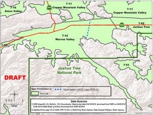
23 CCR §340.4 States that a “clear and unambiguous written description of a basin or subbasin boundary in Bulletin 118 shall prevail over any inconsistent basin or subbasin boundary as depicted on a map, in an electronic data file, or otherwise, except when modified pursuant to these regulations.” The Mojave Water Agency (MWA), in cooperation with our partners Hi-Desert Water District (HDWD) and Joshua Basin Water District (JBWD), has proposed a science-based boundary modification for Warren Valley Groundwater Basin 7-12 (Warren Valley Basin) as designated by DWR’s Bulletin 118, Update 2003. The purpose of this proposed Basin Boundary Modification Request for the Warren Valley Basin is to bring the eastern basin boundary into alignment with the written description of the Warren Valley Basin provided in Bulletin 118, Update 2003. The location of the eastern boundary of Warren Valley Basin in the Final 2016 Bulletin 118 Groundwater Basin Boundaries shapefile is inconsistent with the “Yucca barrier” of Lewis (1972), USGS Open-File Report 72-234, as shown in the figure. This proposed boundary modification request is an administrative adjustment to bring the graphically drawn basin boundary into alignment with the written description of the Warren Valley Basin provided in DWR’s Bulletin 118, Update 2003, as required by 23 CCR §340.4.
From the Basin Boundary Modification Emergency Regulations
§ 343.12. Public Input(a) Any person may provide information to support or oppose a proposed boundary modification request as follows:(1) Public input must be submitted by written notice to the Department within 30 days after the Department posts a notice that the request is complete pursuant to Section 343.10(c), and provide the requesting agency a duplicate copy of that information the same day.(2) Public input must include the name, address, and electronic mail address of the person or entity providing that input.(3) Public input must include a clear statement of the basis for the support of or opposition to the proposed boundary modification.(4) The level of detail provided by public input need not be as comprehensive as that contained in the request, but must rely on similar scientific and technical information as the particular boundary modification request to which it is addressed, and will be evaluated by the Department using the same criteria.(b) The Department shall post all public input on the Department’s Internet Web site.(c) The Department is not required to respond to comments received through public input, but will consider such comments as part of its evaluation of a boundary modification request.(d) The Department shall give the requesting agency a reasonable opportunity to respond to public input, including the opportunity to modify the boundary modification request.Note: Authority cited: Section 10722.2, Water Code.Reference: Section 10722.2, Water Code.